As one of the two main areas of investigation in the NoeSLIDE project, the Salcher landslide in Gresten was equipped with a large number of different installations to investigate the subsurface.
Permanently installed since the start of the field work in 2015 to date:
- 3 TDR probes (each at 0.5, 1 and 2 m depth; soil water content in [%])
- 5 piezometers (depth between 4 m and 8 m; height of the water column in [m])
- 1 automatic inclinometer (13 m)
- 2 manual inclinometers (~ 6.5 and 8.5m, sheared off in 2018)
- 3 manual inclinometers (~ 4 to ~ 4.65m)
Inclinometer
There are currently 4 cased boreholes on the Salcher landslide, which are used for inclinometer measurements. 3 are measured approximately once a month using manual inclinometer probes, one includes a permanently installed chain inclinometer. The measurements take place here automatically and are read out directly via the internet and sent to the server in Vienna.
In the summer of 2019, 3 new inclinometers and a new piezometer were installed. The old manual inclinometers were sheared off by the movement of the slope. For field work see also Figure 18. In 2022, another inclinometer was set because one was lost due to slope movement.
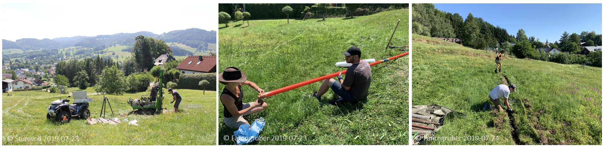
Figure 18: Site work on the Salcher landslide, July 2019. © Photographs see individual notes.
Piezometer and TDR probes
Five piezometers are installed at the Salcher landslide. Four are located along a longitudinal profile of the landslide, another is located along an upper transverse profile. Right next to the meteorological station, 3 TDR probes are installed at depths of 0.5, 1 and 2 m. Measurements are conducted every 5 minutes.
The data on these sensors can be called up here in Monitoring.
Permanent Electrical Resistivity Tomography (ERT)
A permanent ERT ist installed at the site by the Geological Survey of Austria (GBA). It is buried over the entire length of the landslide at a depth of approx. 30 cm and operates in an automated mode. The GBA's GEOMON system is used here (Supper et al. 2014). The ERT was installed as part of the LAMOND project (Ottowitz et al. 2018) in autumn 2014. Measurements are conducted every three hours, whereby changes in the moisture conditions in the subsurface can be recorded. Figure 17 shows a representative example of an ERT measurement on the Salcher landslide. For more details see Ottowitz et al. 2018.
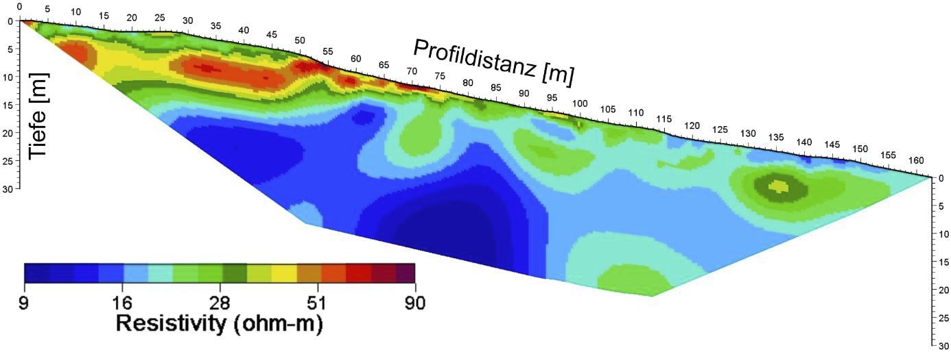
Figure 19: Representative result of the geoelectric monitoring profile of the GBA at the Salcher landslide - calculated model of the specific electrical resistance. Graphic from Ottowitz et al. 2018.
Dynamic probing heavy (DPH), percussion drilling, core sampling and laboratory analysis
At the beginning of the NoeSLIDE project in 2014, a large number of core samples down to a depth of 14 meters were obtained using percussion drilling. For field work see also Figure 20.
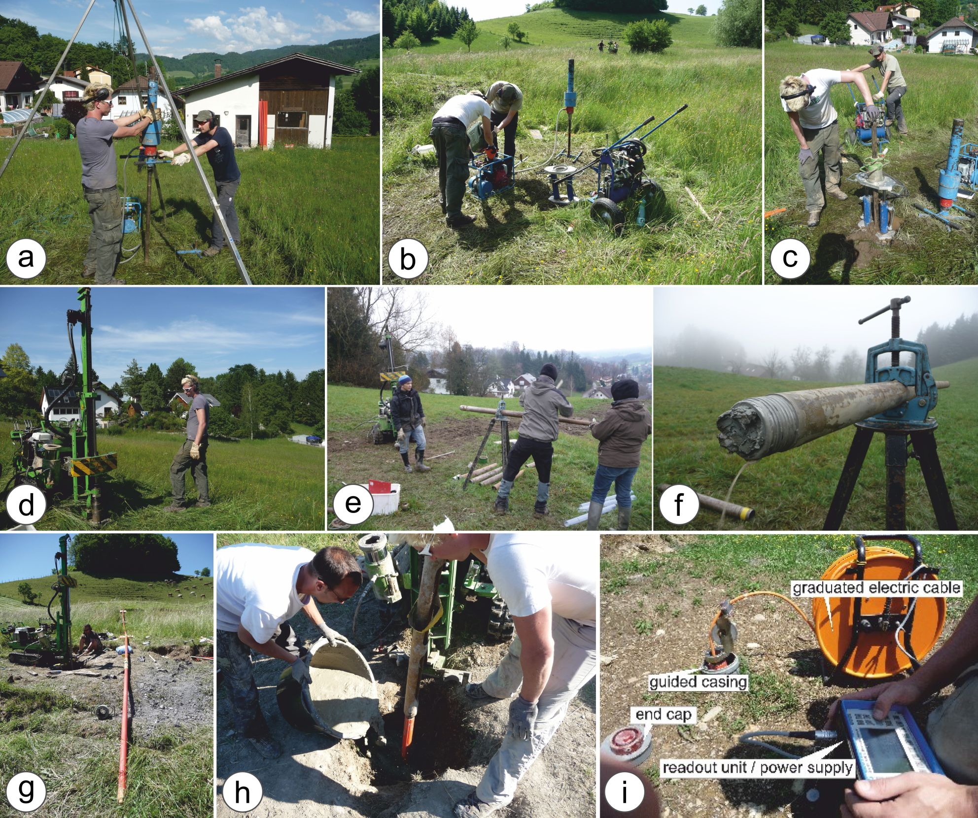
Figure 20: Field work on the Salcher landslide 2014/2015. A-c) Dynamic probing (DPH); d-e) Percussion drilling and core sampling; f) water leakage at drill core B6; g-h) inclinometer installation; i) Inclinometer data acquisition. Graphic from Stumvoll et al. 2019.
The corresponding soil samples were then examined in the soil physics laboratory at the University of Vienna with regard to grain size distribution, storage conditions, color, lime- and water content.
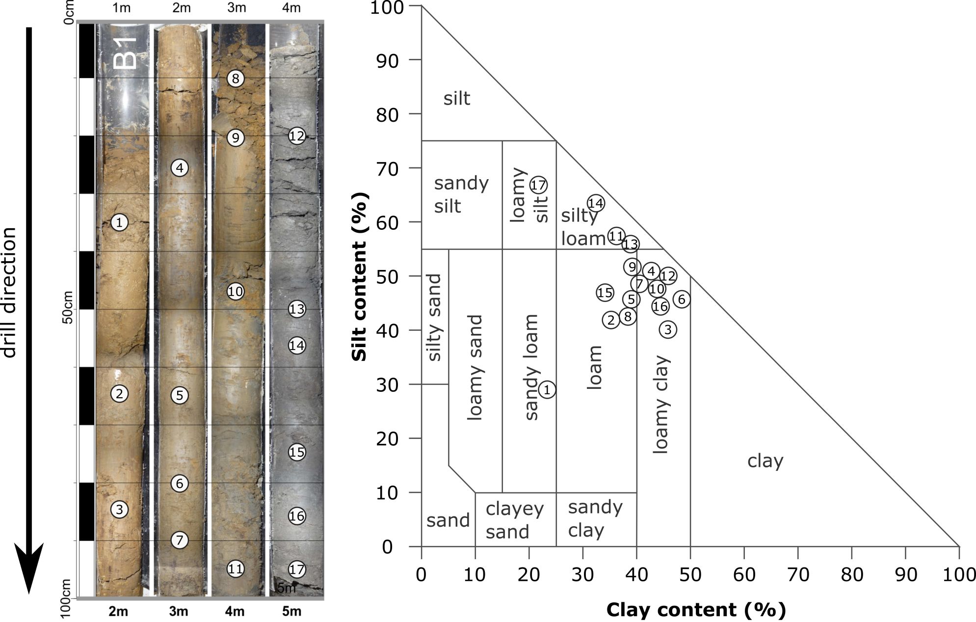
Figure 21: Example for the analysis of a drill core (B1) on the Salcher landslide according to ÖNORM L1050. Graphic from Stumvoll et al. 2019.
Changes in the bulk density in the subsurface were determined by means of dynamic probing. In conjunction with the drill core analyses, these probings can be used to get an impression of the subsurface structure of the slope (see Figure 22).
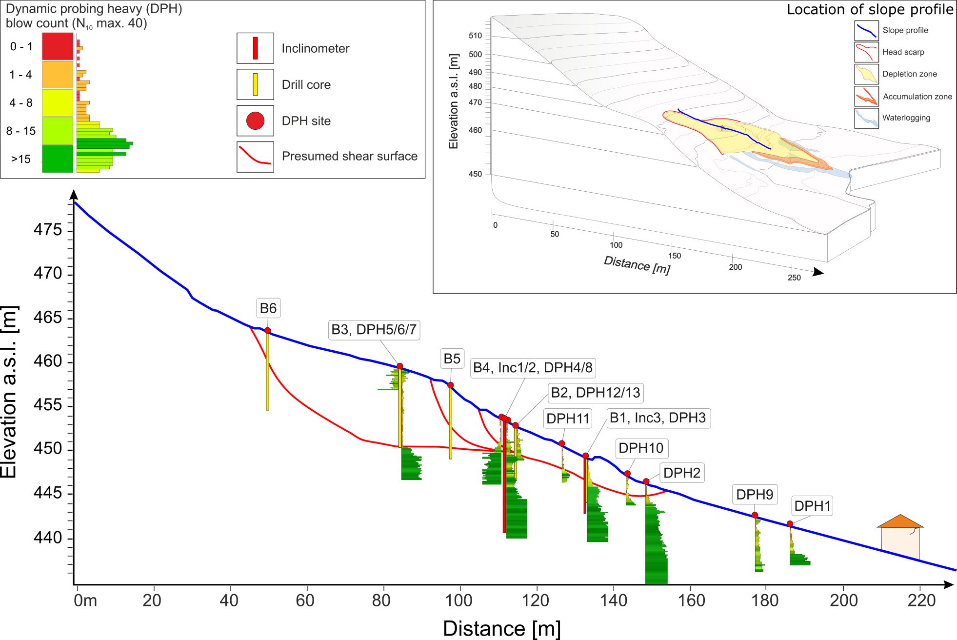
Figure 22: Subsurface model of the Salcher landslide using inclinometer, dynamic probing and percussion drilling. Graphic from Stumvoll et al. 2019.
Literature
Engels, A. 2015. Landslide dynamics -From historical data to monitoring systems: an approach in Gresten, Lower Austria (Masterthesis; unpublished). 173. Vienna, Austria: University of Vienna.Ottowitz, D., S. Hoyer, B. Jochum, M. Riegler, P. Preuner, A. Scolobig & R. Supper (2018) Long-term landslide monitoring for understanding of underlying dynamic processes as basis for an End-User focused early warning – LAMOND. Wien, Österreich: Geologische Bundesansalt Fachabteilung Geophysik. 10.1553/ESS-LAMOND.Stumvoll, M. J., E. Canli, A. Engels, B. Thiebes, B. Groiss, T. Glade, J. Schweigl & M. Bertagnoli (2019) The “Salcher” landslide observatory—experimental long-term monitoring in the Flysch Zone of Lower Austria. Bulletin of Engineering Geology and the Environment, 18. 10.1007/s10064-019-01632-wSupper, R. et al., 2014. Geoelectrical monitoring: an innovative method to supplement landslide surveillance and early warning. Near Surface Geophysics, 12(1), pp.133–150.