The "Hofermühle" site is located in the hydrological catchment of the Redtenbach in Konradsheim, town and district of Waidhofen an der Ybbs, Province of Lower Austria. Similar to the location of the Salcher landslide in Gresten, the Hofermühle is located in a complex geological transition zone between Calcerous Alps (Oberostalpin) in the south and Flysch Zone (Penninikum) and Helvetikum in the north (see, among others, Ruttner & Schnabel 1988, Schnabel 1980 or Schnabel 1999). Due to the high proportion of clayey-marl-like material and its high degree of weathering, the Flysch Zone has the highest density of sliding processes in Lower Austria (Schwenk 1992, Schweigl & Hervas 2009, Petschko et al. 2014).
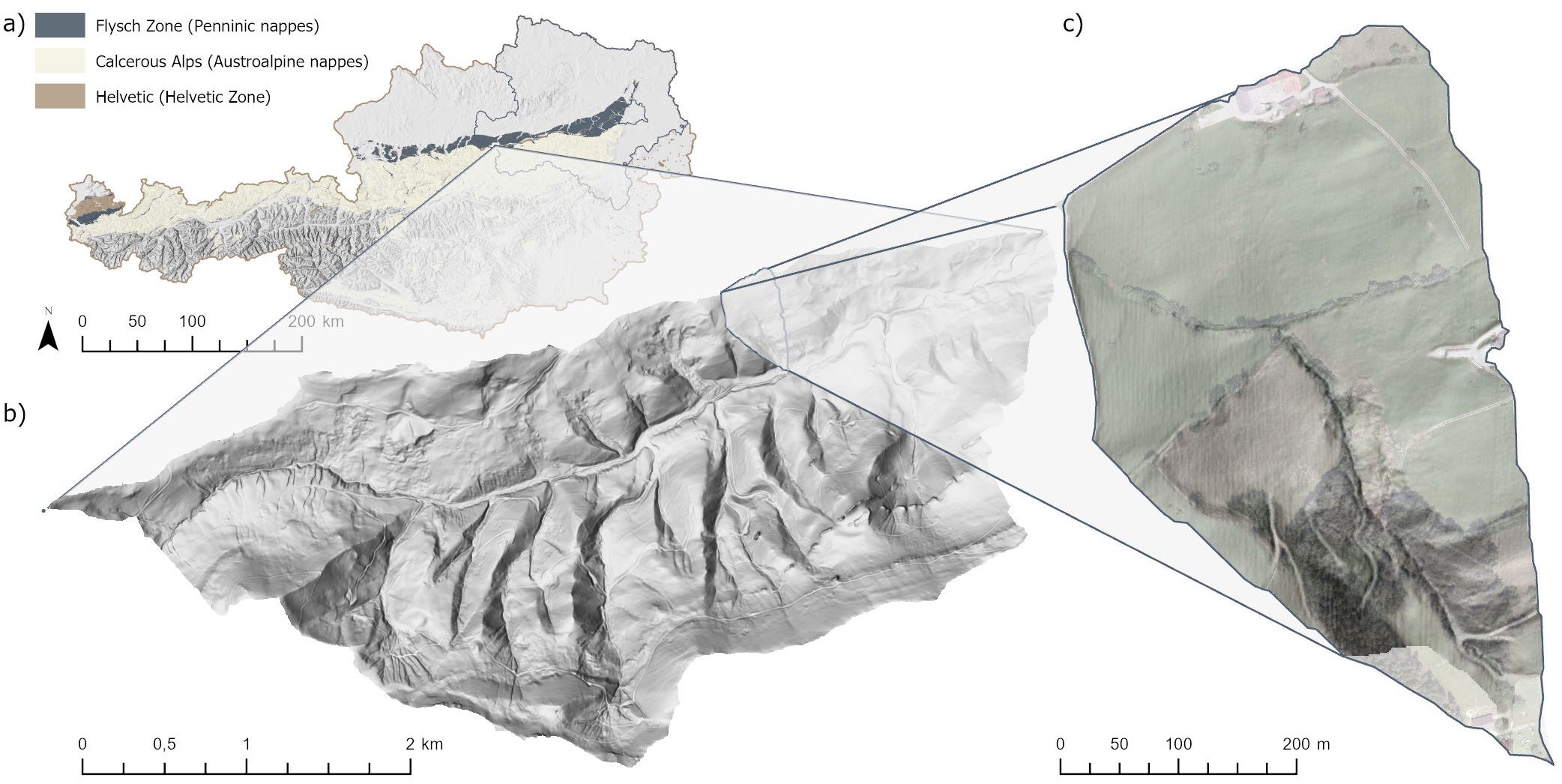
Figure 5: a) Location of the NoeSLIDE site "Hofermühle" in Austria; b) Location of the hydrological catchment of the Hofermühl torrent in the Redtenbach catchment ; c) hydrological catchment of the Hofermühl torrent. (DEM (10 m): BMDW 2017 (www.data.gv.at), geological map 1: 500 000 according to Weber (1997), DEM (1 m) 2009 and orthophoto 2011: provided by the Federal State Government of Lower Austria). Graphics: Stumvoll M.J. 2020.
The processes at the site are complex; areas with very slow and shallow rotational and translational sliding processes are connected to a torrential system, which can also lead to faster processes such as debris flow. The first landslide activities were documented on the orographic right of the torrent at the end of the 1970s; drainage and afforestation were the consequence. In 2011 sliding processes on the orographic left side were recognized; in 2013 these processes accumulated and led to a coupled debris flow along the Hofermühl torrent path (Sausgruber 2013). In a report by the WLV from 2016, the area affected by the entire landslide process is estimated at around 50.000 m² (Sausgruber 2016). In order to anticipate the danger for the adjacent farm house which could be caused by a reactivation of the torrential system, the WLV built a dam at the outlet of the Hofermühl torrent in 2019/2020. In addition, the active landslide area in the upper catchment was roughly drained using superficial trenches (December 2019).
The Hofermühle site has been part of the NoeSLIDE monitoring project since 2014 and is being investigated using a variety of different methods and techniques. Details can be found in the two sub-tabs on subsurface and surface monitoring.
Literature
Petschko, H., A. Brenning, R. Bell, J. Goetz & T. Glade. 2014. Assessing the quality of landslide susceptibility maps - case study Lower Austria. Natural Hazards and Earth System Sciences, 14, 95-118. 10.5194/nhess-14-95-2014Ruttner, A. & W. Schnabel. 1988. Geologische Karte der Republik Österreich 1:50.000 Blatt 71 Ybbsitz. Wien: Geologische Bundesanstalt.Sausgruber, T. 2013. Hofermühlrutschung Waidhofen/ Ybbs (intern). Mit zwei Anhängen (Kartierung). 12. Innsbruck, Austria: Forsttechnischer Dienst für Wildbach und Lawinenverbauung. Geologische Stelle. Innsbruck, Austria.Sausgruber, T. 2016. Protokoll zum Lokalaugenschein Hangprozess Hofermühle / Hofermühlrutschung. Mit einem Anhang (Kartierung). 4. Innsbruck, Austria: Forsttechnischer Dienst für Wildbach und Lawinenverbauung. Geologische Stelle. Innsbruck, AustriaSchnabel, W. 1980. Die Geologie des Voralpengebietes im Abschnitt Waidhofen an der Ybbs - Ybbsitz - Gresten. In Waidhofner Heimatblätter, 13-27. Waidhofen, Ybbs: Musealverein Waidhofen an der Ybbs.Schnabel, W. 1999. The Flysch Zone of the Eastern Alps. In FOREGS '99 <Vienna>, Field trip guide Vienna - Dachstein - Hallstatt - Salzkammergut (UNESCO World Heritage Area), August 30th - September 2nd, 1999: 150 Years Geological Survey of Austria, ed. G. W. Mandl, 27-35. Wien: Verlag der Geologischen Bundesanstalt (GBA).Schweigl, J. & J. Hervás. 2009. Landslide Mapping in Austria. In Scientific and Technical Research series, 61. Joint Research Centre – Institute for Environment and SustainabilitySchwenk, H. (1992) Massenbewegungen in Niederösterreich 1953 - 1990. Jahrbuch der Geologischen Bundesanstalt, 135, 597-660.Stumvoll, M. J. & T. Glade. 2019. MillSLIDE - Monitoring der Hofermühle.- Interner Projektbericht für die Wildbach- und Lawinenverbauung, Forsttechnischer Dienst Niederösterreich West. 32. Wien: Universität Wien, Institut für Geographie und Regionalforschung.Weber, L. 1997. Flächendeckende Beschreibung der Geologie von Österreich 1:500.000 im Vektorformat. Exzerpt (Basiskarte Geologie) aus der Metallogenetischen Karte von Österreich 1:500.000. Wien, Österreich: Geologische Bundesanstalt.