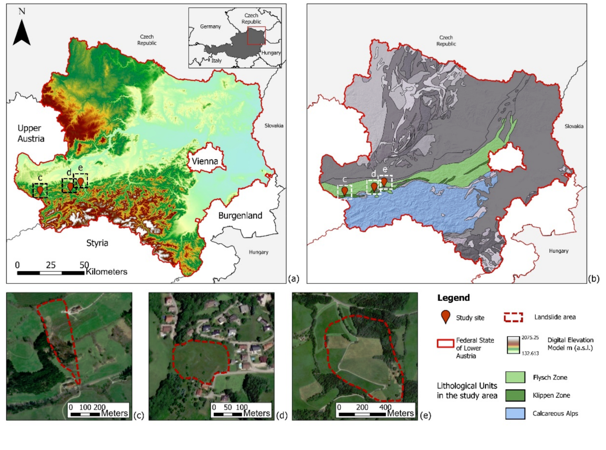
Figure 5: Location of the landslide observatories and areas of investigation in Lower Austria. (a) Location of the Lower Austria federal state, in north-eastern Austria. Relief shading is based on the Austrian 10 m DEM; (b) Geological map in which the lithological units reported are of major interest for the study area (after Weber, 1997); (c–e) Location of the (c) Hofermühle, (d) Gresten, and (e) Brandstatt observatory, respectively, as well as areas affected by landslide displacements in recent years (Marr et al., 2023).
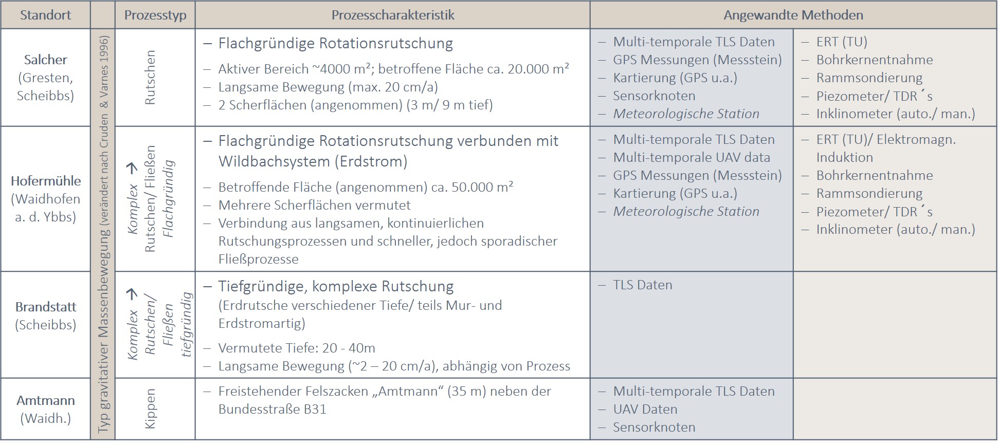
Six sites were initially involved in the investigations of the NoeSLIDE project (see Figure 4). Some of them are examined at irregular intervals without automatic measuring systems, some of them very intensively with their own power and broadband internet connection. Currently 2 of the 6 sites are still being closely monitored, the others have been completed. The six sites, which are spread across the Waidhofen / Ybbs, Amstetten and Scheibbs districts, are:
- Salcher landslide (ongoing)
One of the main research sites in the NoeSLIDE project is located in Gresten (district Scheibbs). This study site has its own page with detailed information; please refer Salcher Landslide Observatory. - Hofermühle earth slide - earth flow (ongoing)
The second main investigation site is the Hofermühle landslide in Konradsheim (Waidhofen an der Ybbs district). A separate page is also dedicated to this location, see Hofermühle. - Brandstatt landslide (ongoing)
The third main investigation site in Brandstatt (district of Scheibbs) was equipped with various monitoring systems in the summer of 2022. Detailed information can be found on the "Brandstatt site" page.The Brandstatt landslide is a large-scale and deep seated landslide coupled with smaller and more superficial processes. The movement rates are low but have a high damaging effect. The area was therefore i.a. investigated by the GBA on behalf of the Geological Office of Lower Austria. In order to investigate superficial changes, the area was recorded using TLS as part of the NoeSLIDE project. - Eckerwirt mudflow (completed)
The Eckerwirt location is only a few hundred meters west of the Hofermühle location in Konradsheim and is very similar to it, but somewhat larger in size. Due to its activity (mudflow) it has already been extensively investigated by the Geological Office of the Federal State Government of Lower Austria, the Torrent and Avalanche Control (Wildbach und Lawinenverbauung WLV) and the Geological Survey (Geologische Bundesanstalt GBA). In order to determine any surface changes, this area was included in the course of the TLS measurements at the Hofermühle. - Amtmann rock fall / tipping (completed)
The Amtmann is an approximately 30m high, free-standing rock formation in the Ybbstal valley and situated only a few meters from the busy Ofenlochstraße (B31). As a natural monument, the structure cannot be removed; it is therefore investigated at regular intervals by the Amstetten road construction authority. In order to investigate possible movements of the rock tower (tilting tendencies, vibrations), a wireless sensor node network was installed on the rock. The evaluation of multi-temporal TLS data was, among other things, used to investigate possible fall processes (rockfall) and the formation of gaps. - Ofenloch rock fall / rock fall (completed)
The Ofenlochstraße (B31) between Waidhofen / Ybbs and Opponitz is highly endangered by rock falls. Several technical protective measures have therefore already been installed along this road and are controlled and maintained by the Amstetten road construction authority. In order to be able to determine extensive changes in the corresponding endangered rock faces, a rock face on the right bank of the Ybbs was recorded at regular intervals using TLS as part of the NoeSLIDE project.
Table 2: Overview of the sites investigated in the NoeSLIDE project as well as the respective methodology used to explore the surface and the subsoil. For more details on the Hofermühle in Konradsheim and Salcher Landsliding in Gresten locations, please refer to the corresponding tabs. Table: Stumvoll 2019.
Literature
Cruden, D. M. & D. J. Varnes. 1996. Landslide types and processes. In Landslides: investigation and mitigation, eds. A. K. Turner & R. L. Schuster, 36-75. Washington, D.C.: National Academey Press.Marr, P.; Jiménez Donato, Y.A.; Carraro, E.; Kanta, R.; Glade, T. The Role of Historical Data to Investigate Slow-Moving Landslides by Long-Term Monitoring Systems in Lower Austria. Land 2023, 12, 659. https://doi.org/10.3390/land12030659Weber, L. 1997. Flächendeckende Beschreibung der Geologie von Österreich 1:500.000 im Vektorformat. Exzerpt (Basiskarte Geologie) aus der Metallogenetischen Karte von Österreich 1:500.000. Wien, Österreich: Geologische Bundesanstalt.
")
")